Home > Magazine > Cover Story > Driving Through the Himalayas
 In the upper reaches of Himachal Pradesh, beyond Kiber (the highest motorable
village) and the barren splendor of Spiti and its majestic monasteries lies the
rugged and pristine Lahaul valley, where the landscape itself is celestial.
In the upper reaches of Himachal Pradesh, beyond Kiber (the highest motorable
village) and the barren splendor of Spiti and its majestic monasteries lies the
rugged and pristine Lahaul valley, where the landscape itself is celestial.
It’s a magical journey through two high Himalayan passes and the verdant Lahaul valley. Starting from Kaza, the district town of Spiti and the tourist town of Manali in Kullu valley, the journey comprises 185 km of almost uninhabited yet mesmerizing Himalayan terrain. But then, if you are fond of driving, have your own wheels—two, four or even hired ones—and love the mountains, then this high-altitude terrain is a gift for the senses and the spirit.
We reach Kaza, the district headquarters of Spiti, from New Delhi after a gratifying four-day journey. The mountains have already cast their spell but the best is yet to come. Two passes—Kunzum La (4590 m) to the east and Rohtang (3978 m) to the west—control the access to Lahaul valley and remain closed for around six months of the year in the winter due to snow. We have one day to traverse through two high-altitude passes and the forbidding terrain of Lahaul valley. As while walking, so while driving, the journey is best enjoyed at your own pace. Yet the daunting 185 km ahead pushes us for an early start.
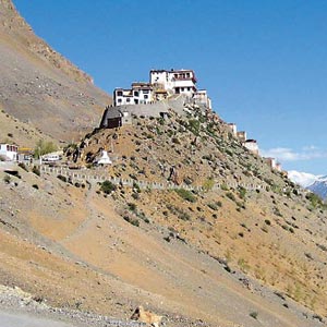
We leave behind the Ki Gompa, the jewel of the Spiti valley. Bathed in the morning light, it looks majestic, almost as a preamble to what waits to unfold.
Even as the first morning rays kiss the roads, tiny rivulets of the morning melt make the drive treacherous as they fill little pools in the potholes and make the almost frozen roads slippery. As we head for the Kunzum La pass we leave behind the river Spiti that originates near the pass.
Crossing over the Spiti River, we begin the first leg of our day’s journey, the 76 km climb to Kunzum La, Tibetan for “Meeting Point of the Ibex, the mountain goat” and the eastern entry point into the picturesque Lahaul valley.
The magic begins even before you reach the mountain pass. Having just left behind alpine meadows, flat green table lands and barren brown peaks, we take that treacherous turn on the road and chance on snow in the crevices. The excitement for a person used to the plains and escaping the 45 degrees Celsius heat of a dusty Delhi summer is tangible.
A couple of hours go by as we drive through wide valleys dotted with grazing yaks and small villages. Several villages have small boards mentioning the population of the village in simple hundreds and sometimes even less than a hundred. The average population density of Lahaul and Spiti district is 2 persons per km.
We touch Losar, a small township, and the last in Spiti. It’s ten in the morning. The glassful of coffee and aloo paranthas, hot, served in the only shack by the roadside, are immensely satisfying.
The village is small and we are in the middle of a small traffic jam at a rather imposing police checkpoint. Some men lounge on a porch in the morning sun. The women are busy with household work. Hardly anyone wears the customary Tibetan skirt and apron. The ubiquitous salwar kameez has made deep inroads. The town, perhaps an ancient crossroad on the silk route, has cheap products of the modern plastic culture in shop fronts. Yet, the serenity of the mountains overshadows it all.
We drive on. The serpentine, now-climbing, now-dipping road is perilous and flush with the morning melt. At this point we did not know that we would soon be driving through gushing streams of glacial melt.
Soon the landscape is turning more white than brown. We experience intermittent breathlessness. Is it the altitude or the breathtaking view?
The white is pristine. Pure. All around us. The climb to Kunzum La is nearly 11 km. A milestone shows up alongside a chorten (a monument to a distinguished Buddhist, especially a lama) of stones: “Kunzum La 2 km!”
We slow down to absorb the grandeur.
The sun is bright, and the sky as blue as can be. We touch Kunzum La. They say the pass is best crossed in the forenoon. We reach there a little after noon. At this Himalayan pass both ascent and descent are fairly gentle and the panoramic views from the crest are phenomenal!
The crest of the pass is marked by a mani wall, made of rounded flat stones on which the Tibetan Buddhist mantra “Om mani padme hum” is engraved. The wall surrounds the shrine and is covered in snow. The colorful Buddhist flags at the shrine dedicated to Geypan, the presiding deity, are the only things that break the white snowy expanse. According to legend, cash offerings made by true believers stick to the stone image of the deity, signifying the acceptance of the offering.
It is considered auspicious to circumambulate the shrine before proceeding. We walk around the shrine and pause for a few moments at this roof of the world.
The high-altitude road makes a slow descent towards Lahaul valley. A subdivision of the trans-Himalayan Lahaul-Spiti district, the valley unfolds amid a row of high mountains in resplendent colors of purple and green. The melting glaciers have left a debris of crushed rock, with the white of the glaciers playing with shiny mountain slopes and turning the river in the deep gorge emerald green.
It’s a 60-km drive through Lahaul to the Rohtang pass. The name of the valley, they say, derives from the Tibetan “Loh Yul” (southern country of Ladakh) or “Lhahi Yul” (country of the gods). Bound on the North-South axis to Ladakh to the north and the Pir Panjal range to the South on the Indo-Tibet border, Lahaul is one subdivision of the trans-Himalayan Lahaul-Spiti district, the other being Spiti.
The Chandra River flows from the west of the Kunzum La pass. A six-km trek from the road head connects you to Chandratal, the lake of the Moon, the source of the Chandra River that cuts through the Lahaul valley.
Strange, exciting, and primitive, the mountain scape of this valley on the Indo-Tibetan border is unsurpassed in the rugged beauty of its rocky escapements and the splendor of its snow-covered peaks, which form the theatre for the graceful dance of the Chandra.
The perennial snow peaks of the Great Himalayas, the highest of the three Himalyan ranges, cradle this mesmerizing valley formed by the Chandra and Bhaga Rivers.
The sheer scale of nature’s artful landscape, bathed in and enhanced by the distilled light, makes one realize how miniscule one is in the larger scheme. Its raw beauty, on the other hand, makes you feel a part of a grand, larger design.
Lahaul is marked by a central mass of uniformly high mountains and massive glaciers that were in a fierce melt in the summer. We drive through several of these glaciers where the Border Roads Organisations maintains a constant vigil and carries out maintenance work.
Car tracks through the stony bed of the valley, through the shallows of the rivers and through glaciers that are turning into ebullient mountain streams and waterfalls, make the journey exhilarating and tantalizing at the same time.
The tracks move through snow and through riverbeds, with herds of sheep as the only traffic. The Gaddi shepherds herding their herds of mountain sheep and carrying their homes on their backs are masters of survival in this harsh though magnificent terrain.
Batal, almost midway between Kunzum La and Rohtang, is the only pit stop. Its pristine beauty is rather deceptive. Extreme chill winds sweep this place, which is also the base point for short treks in the valley. Batal offers inspiring views of a slender triangular peak to the south and the Bara Shigri Glacier. Chhota Shigri Glacier and Gramphu are next as we proceed towards Rohtang La.
The road climbs up again gradually. Waterfalls dot the crevices in the mountainous walls of the valley as we leave the Chandra below and head for Gramphu, where the road bifurcates for Ladakh via Keylong, the district headquarters of Lahaul and towards Manali through Rohtang. It’s the latter that we take.
Rohtang pass, though lower than Kunzum La, is more rugged for its steep rise, hairpin bends and bad weather. In Tibetan Rohtang literally translates as “a pile of corpses.” As we head towards peaks piercing through the cloud line, a thick fog envelops the top of the pass. It allows us only glimpses of the majesty of the Pir Panjal Mountains.
On the other side of Rohtang, after a 51-km drive down the verdant hills of Manali, with its pine forests and numerous waterfalls, we head for the humid, green and congested town, our last stop on the way home.
Yet the grandeur of Lahaul sustains. Driving through the mountainous ramparts with an ebullient river by your side, the isolated beauty and tranquil silence of this valley remain an elemental experience. Being face to face with all that is pure, pristine, raw and rarefied as reflected in those white mountains, I felt so one with myself.
blog comments powered by Disqus
Driving Through the Himalayas
By: Aparna Srivastava Reddy 
March 2011
In the upper reaches of Himachal Pradesh, beyond Kiber (the highest motorable
village) and the barren splendor of Spiti and its majestic monasteries lies the
rugged and pristine Lahaul valley, where the landscape itself is celestial.
It’s a magical journey through two high Himalayan passes and the verdant Lahaul valley. Starting from Kaza, the district town of Spiti and the tourist town of Manali in Kullu valley, the journey comprises 185 km of almost uninhabited yet mesmerizing Himalayan terrain. But then, if you are fond of driving, have your own wheels—two, four or even hired ones—and love the mountains, then this high-altitude terrain is a gift for the senses and the spirit.
We reach Kaza, the district headquarters of Spiti, from New Delhi after a gratifying four-day journey. The mountains have already cast their spell but the best is yet to come. Two passes—Kunzum La (4590 m) to the east and Rohtang (3978 m) to the west—control the access to Lahaul valley and remain closed for around six months of the year in the winter due to snow. We have one day to traverse through two high-altitude passes and the forbidding terrain of Lahaul valley. As while walking, so while driving, the journey is best enjoyed at your own pace. Yet the daunting 185 km ahead pushes us for an early start.
We leave behind the Ki Gompa, the jewel of the Spiti valley. Bathed in the morning light, it looks majestic, almost as a preamble to what waits to unfold.
Even as the first morning rays kiss the roads, tiny rivulets of the morning melt make the drive treacherous as they fill little pools in the potholes and make the almost frozen roads slippery. As we head for the Kunzum La pass we leave behind the river Spiti that originates near the pass.
Crossing over the Spiti River, we begin the first leg of our day’s journey, the 76 km climb to Kunzum La, Tibetan for “Meeting Point of the Ibex, the mountain goat” and the eastern entry point into the picturesque Lahaul valley.
The magic begins even before you reach the mountain pass. Having just left behind alpine meadows, flat green table lands and barren brown peaks, we take that treacherous turn on the road and chance on snow in the crevices. The excitement for a person used to the plains and escaping the 45 degrees Celsius heat of a dusty Delhi summer is tangible.
A couple of hours go by as we drive through wide valleys dotted with grazing yaks and small villages. Several villages have small boards mentioning the population of the village in simple hundreds and sometimes even less than a hundred. The average population density of Lahaul and Spiti district is 2 persons per km.
We touch Losar, a small township, and the last in Spiti. It’s ten in the morning. The glassful of coffee and aloo paranthas, hot, served in the only shack by the roadside, are immensely satisfying.
The village is small and we are in the middle of a small traffic jam at a rather imposing police checkpoint. Some men lounge on a porch in the morning sun. The women are busy with household work. Hardly anyone wears the customary Tibetan skirt and apron. The ubiquitous salwar kameez has made deep inroads. The town, perhaps an ancient crossroad on the silk route, has cheap products of the modern plastic culture in shop fronts. Yet, the serenity of the mountains overshadows it all.
We drive on. The serpentine, now-climbing, now-dipping road is perilous and flush with the morning melt. At this point we did not know that we would soon be driving through gushing streams of glacial melt.
Soon the landscape is turning more white than brown. We experience intermittent breathlessness. Is it the altitude or the breathtaking view?
The white is pristine. Pure. All around us. The climb to Kunzum La is nearly 11 km. A milestone shows up alongside a chorten (a monument to a distinguished Buddhist, especially a lama) of stones: “Kunzum La 2 km!”
We slow down to absorb the grandeur.
The sun is bright, and the sky as blue as can be. We touch Kunzum La. They say the pass is best crossed in the forenoon. We reach there a little after noon. At this Himalayan pass both ascent and descent are fairly gentle and the panoramic views from the crest are phenomenal!
The crest of the pass is marked by a mani wall, made of rounded flat stones on which the Tibetan Buddhist mantra “Om mani padme hum” is engraved. The wall surrounds the shrine and is covered in snow. The colorful Buddhist flags at the shrine dedicated to Geypan, the presiding deity, are the only things that break the white snowy expanse. According to legend, cash offerings made by true believers stick to the stone image of the deity, signifying the acceptance of the offering.
It is considered auspicious to circumambulate the shrine before proceeding. We walk around the shrine and pause for a few moments at this roof of the world.
The high-altitude road makes a slow descent towards Lahaul valley. A subdivision of the trans-Himalayan Lahaul-Spiti district, the valley unfolds amid a row of high mountains in resplendent colors of purple and green. The melting glaciers have left a debris of crushed rock, with the white of the glaciers playing with shiny mountain slopes and turning the river in the deep gorge emerald green.
It’s a 60-km drive through Lahaul to the Rohtang pass. The name of the valley, they say, derives from the Tibetan “Loh Yul” (southern country of Ladakh) or “Lhahi Yul” (country of the gods). Bound on the North-South axis to Ladakh to the north and the Pir Panjal range to the South on the Indo-Tibet border, Lahaul is one subdivision of the trans-Himalayan Lahaul-Spiti district, the other being Spiti.
The Chandra River flows from the west of the Kunzum La pass. A six-km trek from the road head connects you to Chandratal, the lake of the Moon, the source of the Chandra River that cuts through the Lahaul valley.
Strange, exciting, and primitive, the mountain scape of this valley on the Indo-Tibetan border is unsurpassed in the rugged beauty of its rocky escapements and the splendor of its snow-covered peaks, which form the theatre for the graceful dance of the Chandra.
The perennial snow peaks of the Great Himalayas, the highest of the three Himalyan ranges, cradle this mesmerizing valley formed by the Chandra and Bhaga Rivers.
The sheer scale of nature’s artful landscape, bathed in and enhanced by the distilled light, makes one realize how miniscule one is in the larger scheme. Its raw beauty, on the other hand, makes you feel a part of a grand, larger design.
Lahaul is marked by a central mass of uniformly high mountains and massive glaciers that were in a fierce melt in the summer. We drive through several of these glaciers where the Border Roads Organisations maintains a constant vigil and carries out maintenance work.
Car tracks through the stony bed of the valley, through the shallows of the rivers and through glaciers that are turning into ebullient mountain streams and waterfalls, make the journey exhilarating and tantalizing at the same time.
The tracks move through snow and through riverbeds, with herds of sheep as the only traffic. The Gaddi shepherds herding their herds of mountain sheep and carrying their homes on their backs are masters of survival in this harsh though magnificent terrain.
Batal, almost midway between Kunzum La and Rohtang, is the only pit stop. Its pristine beauty is rather deceptive. Extreme chill winds sweep this place, which is also the base point for short treks in the valley. Batal offers inspiring views of a slender triangular peak to the south and the Bara Shigri Glacier. Chhota Shigri Glacier and Gramphu are next as we proceed towards Rohtang La.
The road climbs up again gradually. Waterfalls dot the crevices in the mountainous walls of the valley as we leave the Chandra below and head for Gramphu, where the road bifurcates for Ladakh via Keylong, the district headquarters of Lahaul and towards Manali through Rohtang. It’s the latter that we take.
Rohtang pass, though lower than Kunzum La, is more rugged for its steep rise, hairpin bends and bad weather. In Tibetan Rohtang literally translates as “a pile of corpses.” As we head towards peaks piercing through the cloud line, a thick fog envelops the top of the pass. It allows us only glimpses of the majesty of the Pir Panjal Mountains.
On the other side of Rohtang, after a 51-km drive down the verdant hills of Manali, with its pine forests and numerous waterfalls, we head for the humid, green and congested town, our last stop on the way home.
Yet the grandeur of Lahaul sustains. Driving through the mountainous ramparts with an ebullient river by your side, the isolated beauty and tranquil silence of this valley remain an elemental experience. Being face to face with all that is pure, pristine, raw and rarefied as reflected in those white mountains, I felt so one with myself.
Enjoyed reading Khabar magazine? Subscribe to Khabar and get a full digital copy of this Indian-American community magazine.